 |
| Sask is the worst of the larger provinces (chart from Environment Canada report) |
Will Saskatchewan’s ministers be going? I phoned the offices of Saskatchewan’s Environment Minister, the Hon. Scott Moe, and our Minister of Parks, the Hon. Ken Cheveldayoff today to see if they are planning to attend. The woman who answered the phone in Mr. Cheveldayoff’s office said no, he will not be attending. When I called Scott Moe’s office I spoke to a woman in charge of his calendar and she said she cannot share the minister’s calendar details with the public, although yes he did receive an invitation. But, let’s give him the benefit of the doubt and assume he will be there representing the province in this important discussion.
Why are protected areas important? Well, believe it or not, nature is actually the stuff that makes life possible on the planet—the soil, air, water, climate and species that we depend upon. The earth is running out of landscapes where those ecological goods and services are being protected from the kinds of urban, agricultural, and industrial development that harm them. Protected areas are vital sources of ecological integrity and diversity that we will need more than ever under climate change scenarios of flood and drought.
Over the last twenty-some years Saskatchewan has joined with the rest of Canada in signing a series of national and international agreements on protected areas, beginning with 1992’s United Nations Convention on Biological Diversity. That same year Saskatchewan signed on to the “Statement of Commitment to Complete Canada’s Networks of Protected Areas.” At that time, 12% was set as the target for protecting a percentage of each province’s total area. The intention was to protect that percentage of our forests, grasslands, and wetlands, to ensure representation of the full range of the province’s biodiversity.
Saskatchewan got to work and within five years unveiled its Representative Areas Network (RAN), devising a plan to reach the 12% target by the year 2000. While we were making steady progress in the early years of RAN, we stalled out at 8.7 per cent or 9.7 per cent depending on which report you read. Our grassland ecoregions in the south are stuck at well under 6%.
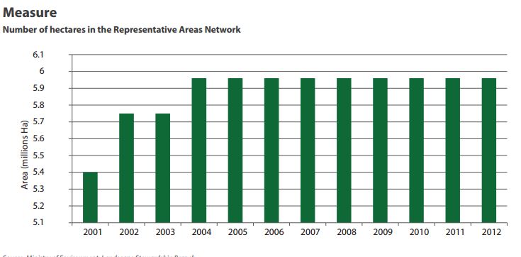 |
| this graph from one of the more recent reports on protected areas posted by Saskatchewan`s Environment Ministry shows that we flat-lined in 2004 |
Meanwhile, the international targets on protection have moved. In 2010 Canada signed the Convention on Biological Diversity, raising the bar to a target of 17% by the year 2020.
So if you were Saskatchewan’s Minister of Environment heading to a meeting to discuss protected areas what would you report? What could you say about what your government has done in recent years and what it plans to do in the next few years?
Well, first you would point to a huge protected area we added to our Representative Areas Network in 2013—the Pink Lake Representative Area Ecological Reserve 160 kilometres north of La Ronge in the Churchill River Upland Ecoregion, the 3600 sq km reserve is our biggest protected area. That addition has the province now claiming that it protects 9.7% of its area—far below the target of 17% and still the worst in Canada excluding the maritimes and NWT.
But believe me it is hard to find any recent reports from Saskatchewan on protected areas progress. However, a friend just today sent me this map recently printed in Canadian Geographic (Walker, N. (2017). ["To preserve and protect: All of Canada's protected areas on one map." Canadian Geographic 137(1): 32-33.) celebrating all of Canada’s wonderful protected areas. ]
 |
| a snip from a map in Canadian Geographic article about protected areas in Canada |
Yep, it is pretty up to date. There’s big ol’ Pink Lake, all fat and sassy up north so I am sure they got the data from the right source--the The CARTS (Conservation Areas Reporting and Tracking System) geodatabase, which is run by the Canadian Council on Ecological Areas.
But, hold on, down in the south there are all these little green dots that look very familiar (red circle in southwest corner on this map). Hey, what the heck!—Saskatchewan is still claiming the federal community pastures as protected areas!
That can’t be. Those pastures, all 1.8 million acres, are being leased out to cattle producers and run entirely for private profit from grazing. They have no support or programming for conservation, and the Province is trying to get the cattle producers to buy them! Manitoba decided to not sell their 20 pastures but even they have de-listed them as protected areas. Either the Sask. government is practicing make believe conservation here or playing fast and loose with the facts to make it look like we are making progress towards our protected areas goals.
Any way you slice it, Saskatchewan should have to remove 1.8 M acres from its protected areas tally. If we were honest and did delete them, this province would have to admit it is actually losing ground in its protected areas effort, and the grassland ecozone, already the least represented, would be looking very thin in any kind of protection—thank God for Grasslands National Park and the Nature Conservancy of Canada’s preserve at Old Man on His Back.
But let’s back up a minute—Saskatchewan doesn’t get all the blame for the loss of protection for the federal pastures. They were a federal responsibility for 75 years after all. Sure it was the Harper government that pulled the plug on the program, but the current administration can’t just shrug its shoulders and walk away from a process that is removing protection from millions of acres of the most endangered ecosystem on the planet.
It is not too late for Ottawa to do something good for the grasslands that Stephen Harper cut loose. This year will see the transfer of the last twenty or so community pastures. These are the big ones with the highest ecological value and the longest lists of species at risk. Most are in the southwest of the province.
One trio—Govenlock, Nashyln, and Battle Creek—together make 812 square kms of grassland right along the Montana border—that’s bigger than Waterton Lakes National Park. There is a terrific opportunity here to grant official protection to the remaining pastures being transferred or at least to those three in the southwest. Failing that, the federal government has a responsibility to find its own way to ensure that the conservation legacy on the former federal pastures is not lost in the handoff from their agriculture ministry to the provinces to the private cattle producers who graze them.
But Saskatchewan has ample opportunity too with the transfer of the pastures to increase its protected areas quotient. It would not be hard—in fact, the Saskatchewan Party in its very first election platform promised us it would establish a new wilderness park. They have not delivered on that yet. We have two wilderness parks already in the north—Clearwater and Athabasca—why not make one in the south?
We could grassland wilderness park along Lake Diefenbaker from up river of sk landing to the bend south of Douglas plus parts of Beechy, Matador, and Monet. Gosh that would look good on a map, and make it a whole lot easier to attend ministerial meetings on protected areas.
 |
| much of that big streak of green along the South Sask River could be included in a grasslands protected area or grassland wilderness park |


No comments:
Post a Comment